Search This Blog

Sunday, February 12, 2012

Manila...


Manila is the capital of the Philippines.  It is one of the sixteen cities forming Metro Manila. Manila is located on the eastern shores of Manila Bay and is bordered by Navotas and Caloocan to the north. Quezon City to the northeast, San Juan and Mandaluyong to the east, Makati on the southeast, and Pasay to the south. 
Manila has a total population of more than 1,660,714 according to the 2007 census.  Manila City is the second most populous city in the Philippines, behind its neighbor, Quezon City. 
Metro Manila is the most populous metropolitan area in the Philippines and the 11th in the world with an estimated population of 16,300,000. The city is divided into six legislative districts and consists of sixteen geographical districts: Binondo, Ermita, Intramuros, Malate, Paco, Pandacan, Port Area, Quiapo, Sampaloc, San Andres, San Miguel, San Nicolas, Santa Ana, Santa Cruz, Santa Mesa and Tondo.  Within their precincts can be found areas of bustling commerce/business centers and some of the most historically and culturally significant iconic landmarks in the country as well as the east of the executive and judicial branches of the government.  It is home to many scientific and educational institutions, as well as numerous sport facilities.  These make the city a major political, commercial, cosmopolitan, cultural, educational, religious, and transportation center of the Philippines.
History
Manila began as a settlement on the banks of the Pasig River, and its name originates from "Maynilad," referring to the mangrove plant known as Nilad, which was abundant in the area. The earliest written account of the city is the 10th century Laguna Copperplate Inscription which describe an Indianized kingdom maintaining diplomatic relations with the Kingdom of Medang and commercial exchanges with Ancient Japan and Song Dynasty China.  The city was invaded by Brunei's Sultan Bolkiah and was already Islamized by the 15th Century. 
Manila eventually became the center of Spanish activity in the Far East and one end of the Manila-Acapulco galleo trade route linking Latin America and Asia.  This caused it to be called the "Pearl of the Orient".  For over 3 centuries Manila was colonized and administered by Spain which left a great architectural heritage throughout  the Philippines, especially with respect to churches, forts and other colonial buildings which can still be seen in the ruins of Intramuros, built in the late 16th century. Several Chinese insurrections, local revolts, a British Occupation and a Sepoy mutiny also occurred thereafter.  Later, it saw the rise of the Philippine Revolution which was followed by the arrival of the Americans who made contributions to the city's urban planning and development only to have most of those improvements lost in the devastation of World War II. Since then the city has been rebuilt.
Climate 
Under the Koppen climate classification system , Manila features a tropical savanna climate that borders on a tropical monsoon climate. Together with the rest of the Philippines, Manila lies entirely within the topics. Its proximity to the equator means that the temperature range is very small, rarely going lower than 20 degrees Celcius and going higher than 38C. However, humidity levels are usually very high which makes it feel much warmer.  It has a distinct, albeit relatively short dry season from January through April, and a relatively lengthy wet season from May through December.
Get in
By train- Manila is crossed by three lines of the Strong Republic Transit System (SRTS), Metro Manila's (partially) integrated railway network: the Yellow and Purple lines, operated by the Light Rail Transit Authority, as well as the Orange Line, operated by the Philippine National Railways. Metro Manila's main passenger train station is Tutuban in Tondo. The PNR operates the Bicol Express daily night train between Manila and Naga in Camarines Sur, as well as nighttime commuter service to Binan in Laguna, which returns to Manila in the early morning.
By bus- Several bus routes to points in Metro Manila and surrounding provinces either pass through or converge in Manila. The city has several bus terminals, with the biggest being the Park and Ride Lawton bus terminal along Padre Burgos St., beside the Manila Metropolitan Theater. Provincial bus companies also operate their own terminals which are dispersed throughout the city. 
By boat- Manila is the hub of the Philippine ferry network, and ferries to most major cities will stop at the Manila South Harbor, the city's main passenger seaport. Several companies operate ferries to Manila from points throughout the Philippines, and cruise ships occasionally stop in Manila throughout the year.


Getting Around - Manila is crossed by three lines of the Strong Republic Transit System (SRTS). Several city and provincial bus routes either cross through or terminate in Manila. Manila is also served by several jeepneys and taxis.


Landmarks
*Baywalk - south of the Luneta is the renovated Baywalk a linear park adjacent to Manila Bay, allows clear view of Manila's legendary sunsets.
*Bonifacio Shrine- A shrine in honour of Andres Bonifacio who was one of the Filipinos who struggled and fought for freedom for the country against the Spanish forces.
*Chinatown - Manila has one of the largest China towns in the world, where one can find exotic Chinese goods and delicious cuisine.
*Intramuros - At the northern end of the Bay lies the remnants of the old walled Spanish settlement of Manila, Intramuros (Spanish for 'within the walls'). Intramuros contains some of the city's most interesting museums, ruins, and churches including the Manila Cathedral, the most important church in the country.
*Manila Hotel - Just outside Intramuros and on the edge of Manila Bay is the beautiful and historic Manila Hotel, a legacy of the American colonial era and the place where General Douglas MacArthur made his home before World War II.
*University of Santo Tomas (UST) - The University is oldest and first University in the whole of Asia and the Philippines. It was used as a camp by the Japanese during their occupation where they imprisoned about 10,000 people even though it only can hold 4,000.
*Manila Metropolitan Theater- is an art deco building designed by Filipino Architect Juan M. de Guzman Arellano and inaugurated on December 10, 1931, with a capacity of 1670. 


Festival
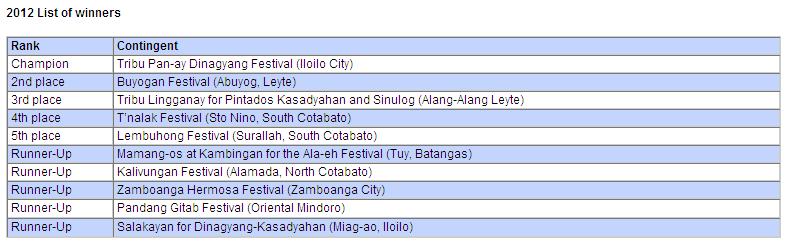
Aliwan Festival also called as "The Mother of All Fiestas" is an event that will feature the famous cultural festival that can be found in the Philippines.  Aliwan is a Tagalog word for "entertainment" or "amusement". This is held during the summer month of the year which is either in April or in May, at Star City Complex in Pasay City.  This is a battle between the best Philippine festivals as the participants dance in a parade with float competitions as well.  This is considered as one of the biggest and loudest festivals in Manila as this touches the different sides of the festival in the Philippines combined.


Disclaimer:
Some information, images, and videos being used on PhilsTravelGuide.blogspot.com are readily available in different website links on the world wide web and believed to be in public domain. As such, contents used in our articles are believed to be posted within our rights according to the U.S. Copyright Fair Use Act (title 17, U.S. Code). 
All images, videos, and information used in this site are copyright of their respective owners.
PhilsTravelGuide claims no credit for them unless otherwise noted.  If you believe that any content appearing on PhilsTravelGuide infringes on your copyright and do not wish them to appear on the site, please contact us and the infringing material will be removed immediately. Thank you.

Friday, February 3, 2012

Cebu...


Cebu is a province in the Philippines, consisting of Cebu Island and 167 surrounding islands.  It is located to the east of Negros, to the west of Leyte and Bohol islands.  Cebu is a long narrow island stretching 225 kilometers from north to south, surrounded  by 167 neighbouring, smaller islands, which include Mactan, Bantayan, Malapascua, Olango and the Camotes Islands.  Cebu has narrow coastlines, limestone plateaus and coastal plains.  It is also has rolling hills and rugged mountain ranges traversing the northern and southern lengths of the island. Its capital is Cebu City, the oldest city in the Philippines, which forms part of the Cebu Metropolitan Area together with four neighbor cities which include Danao City, Lapu-Lapu City, Mandaue City and Talisay City and eight other municipalities. Mactan-Cebu International Airport, located in Mactan island, is the second busiest airport in the Philippines.
Cebu is one of the most developed provinces in the Philippines, with Cebu City as the main center of commerce, trade, education and industry in the Visayas. Cebu City is also known as the Queen City of the South and branded as one of the most livable city, with a population of more than 2 million (census of 2007 whole province of Cebu) , boasts of famed Cebuano hospitality and faith, reputable economic activity, competitive administration and renowned scenic spots. For foreign tourists, it is considered the best mix of modern city convenience with tropical lifestyle.


Festival
Sinulog Festival is one of the grandest and most colorful festivals in the Philippines with a very rich history. The main festival is annually held on the third Sunday of January in Cebu City, Philippines. The festival features some of the country's most colorful displays of pomp and pageantry: participants garbed in bright-colored costumes dance to the rhythm of drums, trumpets, and native gongs.

(Tribu Lingganay of Alangalang, Leyte - Grand Champion Free Interpretation Category, Sinulog Festival 2012)


Climate
Though Cebu has two official seasons, Dry and Wet, rainfall is usually not particularly high.  The wet season usually comes from June to December, while the dry season comes from January until May.  Rainfall is highest in June and July.  Cebu's temperatures can reach a high of 36 degree celsius from March to May, to as low as 18 degrees at the mountains during the cooler season from October to January. The average temperature in Cebu is around 24 to 32 degree celsius, and does not fluctuate much except for the month of May, which is the highest month.  


Landmarks/Tourist spots
* Basilica Minore del Santo Niño- the church was built by Miguel Lopez de Legaspi and Fr. Andres Urdaneta on the site where the image of Santo Niño was found in 1565.
* Fort San Pedro- the smallest and oldest tri-bastion fort in the country. Served as the hub of the Spanish settlement in the Philippines. Has total inner area of 2,025 sq. meters, with the walls being 20 feet high and 8 feet thick. The tower stands approx 30 feet high from the ground level.
* Magellan's Cross - when Magellan traveled from Spain to the Philippines in 1521, he brought with him a wooden cross. This cross was planted at a place called Sugbu, now Cebu, to symbolize the colonization of the  country on behalf of King Philip II of Spain. To preserve the cross the original has been encased in an outer layer of tindalo wood, mounted on a concrete pedestal, and housed in a tile-roofed kiosk. The ceiling of  the kiosk is adorned with a painting depicting the landing of Magellan in Cebu and the planting of the original cross on the shore.
* Lapu Lapu Shrine - inspired by his success in bringing Christianity to the people of Cebu, Ferdinand Magellan crossed the narrow channel to Mactan Island in an effort to spread the Catholic faith. Whilst still wading to the shore, he was killed by island chieftain Lapu Lapu leading his army of men during the battle for supremacy and freedom on April 27, 1521. Magellan's body was never recovered and in 1866 a marker was erected as a monument to this great explorer, marking the spot that Magellan was slain. However this is a nice place to visit, the grounds are very well kept and you can have a  great seafood meal in one of the several fish restaurants next to the shrine.


* Cebu Taoist Temple- preserving the teaching of Lao-Tse, the 600 B.C. Chinese philosopher, the Temple offers a nice break from the hustle and bustle of down town Cebu. 


* Tops - situated around 2,000 feet above sea level up in the cool hills of Busay is Tops.  It is a very popular sight-seeing spot offering a stunning view of Metro Cebu, the island of Mactan and Olango & even Bohol.  There are kiosks available for daytime picnics and instant evening parties.


* Beach resorts
-Malapascua Island is both a peaceful, remote tropical island with an awesome beach, and a diver's paradise destination. There are some fantastic dive sites near the island, the most famous being the Thresher Shark dive. The island is 3 kilometers long and 1 kilometer wide, ideal for swimming and snorkeling. A walk or tour of the whole island can be done within half a day. Malapascua Hotels and Resorts are mostly budget hotels, but the higher end hotels are of good value.
-Bantayan Island is located at the northernmost tip of Cebu mainland and is composed of three municipalities, namely Sta. Fe, Bantayan and Madridejos.  Aside from having one of the oldest churches in the Visayas and Mindanao, it is also known for its massive white sand beaches and crystal clear waters.  Bantayan Hotels and Resorts dotting the island's shores offer a mix of local and international cuisines as well as vast arrays of fresh seafood to choose from. It would take you several days to completely explore the Bantayan Island.
-Moalboal is on the Cebu Island mainland; an easy 90km from Cebu City.  It is famed for some of the best diving in the Philippines, and its white sandy beaches. The nightlife is generally calm and relaxed. During the day, there are waterfalls and caves and other beautiful sights to be explored.


Hotels
There is a wide range of Cebu Hotels and Resorts that cater to tourist and business travelers, and is usually the jumping off point to other Cebu Island hotel destinations. 


Crown Regency Hotel Fuente - At the center of Cebu City, Philippines rises the Fuente Towers, hosting the prestigious Crown Regency Hotel & Towers. The tallest structure outside Metro Manila, the 23-storey, 22,000-square meter Fuente 1 and its equally arresting twin the 38-storey, 36,000-square meter Fuente Tower 2 majestically tower over the Queen City of the South. Its location on Fuente Osmeña and right in the pulse of Cebu City places Crown Regency Hotel and Towers in close proximity to the major points of commerce and recreation. Crown Regency Hotel & Tower is an emblematic marriage of monumental form and high technology.


Marriott Hotel - (5 stars) Located at Cardinal Rosales Avenue, Cebu City, features spacious air-conditioned rooms, fitness center, restaurants, and superb event facilities.


Marco Polo Plaza Cebu - (5 stars)Is located in the prestigious Nivel Hills district where it dominates the Cebu City skyline. The hotel is surrounded by 7.5 hectares of lush greenery, and is 25 minutes from Mactan International Airport and only 10 minutes from the business and commercial centers of Cebu City. The 329 well-appointed guest rooms and suites are equipped with wireless broadband internet.


Radisson Blu Hotel Cebu - Located on the intersection of Sergio Osmeña Boulevard and San Jose de la Montaña Avenue, the Radisson Blu Hotel is the perfect base for exploring the best Cebu City attractions, from white sand beaches and fantastic dive spots to historical sites, such as Magellan's Cross and Colon Street.  With an in-house spa, fitness centre, business centre, 800-meter swimming pool and an exclusive Radisson Club Lounge, guarantees a relaxing stay in the Central Philippines.


Waterfront Cebu City Hotel -It has 562 well-appointed guestrooms with complete room amenities to include minibar, safety deposit box, and centralized air conditioning with individual thermostat control, non-smoking floors, and executive floor.  Room components consist of 2 Presidential suites, 1 Chairman's suite, 1 Penthouse suite, 14 Executive suites, 39 Deluxe suites, 165 Deluxe rooms, 85 superior rooms, 232 standard rooms, 10 Ambassador Suite and 13 Ambassador rooms. The health club has a Fitness Advantage Gym, Swimming pool, and 24-hour Room service massage. Other facilities and services include a Business Center with full convention secretarial support, bank, limousine and car rental, tour and travel counter, shopping arcade, clinic, babysitting, laundry, barber/beauty salon, safety deposit boxes, extensive basement parking and 24-hour casinos.
How to travel to Cebu by Air
Air transportation to and from Cebu is possible nearby as well as internationally.  Amongst the national carriers - Cebu Pacific, Philippine Airlines, Air Philippines, and Zest Air - are the most common airplanes that land at Mactan International Airport. Amongst the international carriers, Silk Air arrives from Singapore.  From Hongkong, the carriers landing in the airport are Cathay Pacific and Cebu Pacific.  Qatar Airways has a direct connection to Mactan Airport from the Middle East countries.  From Manila, direct flights to Cebu are made at the Ninoy Aquino International Airport.
By water - Super Ferry and Negros Navigation are some of the more comfortable means of transportation from Manila or Davao or Iloilo to Cebu.  To go island hopping, bancas (local boats) are the best means of transportation.


Disclaimer:
Some information, images, and videos being used on PhilsTravelGuide.blogspot.com are readily available in different website links on the world wide web and believed to be in public domain. As such, contents used in our articles are believed to be posted within our rights according to the U.S. Copyright Fair Use Act (title 17, U.S. Code). 
All images, videos, and information used in this site are copyright of their respective owners.
PhilsTravelGuide claims no credit for them unless otherwise noted.  If you believe that any content appearing on PhilsTravelGuide infringes on your copyright and do not wish them to appear on the site, please contact us and the infringing material will be removed immediately. Thank you.

Wednesday, February 1, 2012

Leyte...


Leyte is an island in the Visayas region of the Philippines. The island measures about 180km (110mi) north-south and about 65km (40mi) at its widest point.  In the north it nearly joins Samar, separated by the San Juanico Strait, which becomes as narrow as 2km in some places.  To the southern part it is separated from Mindanao by the Surigao Strait.  To the east it is somewhat "set back" from the Philippine Sea of the Pacific Ocean, Samar to the Northeast and Dinagat to the Southeast forming the Leyte Gulf. To the west are Cebu and Bohol.

Leyte is mostly heavily forested and mountainous, but the Leyte Valley in the northeast has much agriculture.  Politically, the island is divided into two provinces: (Northern) Leyte and Southern Leyte. The chief cities of Leyte are Tacloban City, on the eastern shore at the northwest corner of Leyte Gulf, and Ormoc City, on the west coast.  
Today the island is notable for the geothermal electric power plants near Ormoc.  Furthermore, Leyte is most famous for its role in the reconquest of the Philippines in World War II.  On the 20th of October 1944, General Douglas MacArthur waded ashore on Leyte, saying "I have returned".  However, the Japanese did not give up so easily, as the ensuing Battle of Leyte proved, and convergence of naval forces resulted in the four-day Battle of Leyte Gulf, the largest naval battle in history.
Areas of interest
The Leyte Provincial Capitol is the seat of the provincial government where a historic mural depicting the First Mass of Limasawa in the Orient and the landing of Gen. Douglas MacArthur could be seen.
Lake Danao is a violin-shaped lake hemmed by cloud-capped mountain ranges.  It is  a hunter's paradise where wild animals roam the surrounding forests.  It is also said to be the home of a giant eel.
Kalanggaman Island in Palompon, Leyte is a virgin island with pure white side.  It has two long sandbars.  The ecological atmosphere of the island had been preserved by the municipality.


The Sto. Nino Shrine and Heritage Musuem boasts the painting of the 14 station of the cross done by Filipino artists and a bas-relief of the legend of the first Filipino man and woman (Malakas and Maganda).


The San Juanico Bridge is the Longest and the most beautifully designed bridge in the Philippines.  It features the picturesque San Juanico Strait with a thousand whirlpools, lovely islets and view.


Festivals

(Lingganay Festival of Alangalang, Leyte - Grand Champion of Pintados Kasadyaan 2011)


How to get here:
By Air - Philippine Airlines as well as Cebu Pacific has three flights daily, flying from Manila to Tacloban, City. The total travel of time is 1 hour and 10 minutes. Air Philippines likewise has four weekly flights from Cebu - Tacloban, vice versa.
By Land - there are a lot of bus company rendering services on daily basis from the central part of the Philippines to any part of the country. Travel time from Manila-Leyte is 24hours.
By Sea - Trips by Sulpicio Lines going to Tacloban takes about 36 hours. The ship leaves Manila three times a week. The departure day should be arranged one week prior to the trip.


The best time to visit Leyte is during the month of June, especially on its last week, where a lot of festivals are annually celebrated. 


Disclaimer:
Some information, images, and videos being used on PhilsTravelGuide.blogspot.com are readily available in different website links on the world wide web and believed to be in public domain. As such, contents used in our articles are believed to be posted within our rights according to the U.S. Copyright Fair Use Act (title 17, U.S. Code). 
All images, videos, and information used in this site are copyright of their respective owners.
PhilsTravelGuide claims no credit for them unless otherwise noted.  If you believe that any content appearing on PhilsTravelGuide infringes on your copyright and do not wish them to appear on the site, please contact us and the infringing material will be removed immediately. Thank you.

Wednesday, January 25, 2012

Davao...

Davao City  is the largest city in the island of Mindanao in the Philippines. Davao City is also one of several cities in the Philippines that are independent of any province.  The city serves as the regional center for Davao Region (Region XI).  It has a population of 1,530,365 (2011 census), making it the country's largest city outside Metro Manila. Davao City is approximately 588 miles (946km) southeast of Manila, 971km (524nmi) by sea.  The City Mayors Foundation ranks Davao City as the 87th fastest growing city in the world, and it has been listed by the Foreign Direct Investment Magazine as the 10th "Asian City of the Future".  Beaches, diving spots, and mountain resorts are close to the highest peak in the Philippines, Mount Apo. The city was awarded by the Department of Tourism as the Most Livable City in the Philippines in 2008.  


History


Local historians of Davao claim that the word davao came form the phonetic blending of the words three Bagobo subgroups when referring to Davao River, an essential waterway which empties itself into Davao Gulf near the city.  The aboriginal Obos who inhabit the hinterlands of the region called the river, Davoh; the Clatta or Guiangans called it Duhwow, or Davau, and the Tagabawa Bagobos, Dabu.  To the Obos, the word davoh also means a place "beyond the high grounds", alluding to the settlements located at the mouth of Davao River which were surrounded by high rolling hills. When asked where they were going, the usual reply is davoh, while pointing towards the direction of the town.  Duhwow also refers to a trading settlement where they barter their forest goods in exchange for salt or other commodities. 

Spanish influence was hardly felt in Davao until 1848, when an expedition of 70 men and women led by Don Jose Cruz de Uyanguren, a native of Vergara, Guipuzcoa, Spain, came to establish a Christian settlement in an area of mangrove swamps that is now Bolton Riverside.  Davao was then ruled by a chieftain, Datu Bago, who held his settlement at the banks of Davao River (once called Tagloc River by the Bagobos). After Uyanguren defeated Datu Bago, he renamed the region Nueva Guipuzcoa and founded the town Nueva Vergara, which was Davao, in the year 1848, in honor of his home in Spain, and became its first governor.  He himself was reported to have peaceful conquest of the entire venture.  He attempted to make peace with the neighboring tribes - the Bagobos, Mansakas, Manobos, Aetas, etc. - to urge them to help develop the area; his efforts to develop the area, however, did not prosper.
A few years after the American forces landed in 1900, private farm ownership grew and transportation and communication facilities were improved, thus paving the way for the region's economic growth. During the early years of American rule which began in late December 1898 the town began to mark its roles as a new growth center of the Philippines, which it will be a city for the next 38 years.  The American settlers, mostly retired soldiers and investors friends for Zamboanga, Cebu, Manila and the U.S. mainland immediately recognized the rich potential of the region for agricultural investment. 


Climate 
Davao City is typhoon-free due to its location.  The city enjoys a weather that remains balmly all year round.  It is characterized by a uniform distribution of rainfall, temperature, humidity, and air pressure.  It has no pronounced wet or dry season.  Weather predictability makes it highly conducive to agricultural production.  Temperature ranges from 20 to 32  degrees Celsius and average rainfall is up to 2,000mm yearly.


Accessibility:
Davao City is very accessible and is the gateway to the Brunei-Indonesia-Malaysia-Philippines East Asia Growth Area or BIMP-EAGA.


By Land: Davao City also offers a wide bus network connection to major cities and provinces, not only in Mindanao but even as far as Manila and Pasay City in Luzon.  Davao City is connected to Manila by a series of roll on roll off or inter-island ferry connection.  Davao City is accessible by bus to and from points in Mindanao like Cotabato, Monkayo, Kidapawan, Midsayap, Digos, General Santos, Koronadal, Isulan, Tacurong, Tagum, Cagayan de Oro, Surigao, Butuan, and with Manila in Luzon.
By sea: The city is also served by domestic passenger ferries at Sasa Port and Sta. Ana Wharf.
* Sulpicio Lines twice weekly from Manila.
* SuperFerry twice weekly to Manila.
By air: Davao City has direct flights to major cities in the Philippines and some Asian Cities.  Francisco Bangoy Internation Airport (Davao International Airport) is currently being served by the following airline carriers:
* Airphil Express flies to Manila 16 times weekly, Cebu twice daily, Zambaonga four times weekly, thrice weekly to Iloilo City and Cagayan de Oro, once daily.
* Cebu Pacific 4 flights weekly to Cagayan de Oro, 5 daily flights to Cebu City, 2 daily flights to Iloilo City, 8 daily flights to Manila, and Once daily flight to Zambaonga City.
*SilkAir 5 flights weekly to Singapore.
*Zest Airways 2 daily flights to Manila.
* Tiger Airways thrice weekly flights to Singapore.


Tourist Spots
* Battle Memorial - a historical marker of the longest-fought battle between the troops of the American & Filipino forces and of the Japanese Imperial Army which took place in Mintal Tugbok District. (Mintal Elementary School)
*Camp Domingo Leonot - Quarters of the Spanish and later American soldiers in the 1920s. (San Pedro St.)
*City Hall of Davao - The former municipal building constructed in 1926. (San Pedro St.)
*Crocodile Farm - The only crocodile park in the region provides home to locally bred crocodiles including the country's biggest crocodile named Pangil (or fangs) measuring 18feet (5.5m) in length.  On display are also dozens of species of birds and snakes, as well as tigers and great apes. One can take pleasure from viewing, horseback riding around the park, or feeding the young fierce reptiles.
*Davao Historical Society Musuem - Features the historical and indigenous collections of the Davao Historical Society (Magsaysay Park).
*DECA Wakeboard Park - Considered to the the biggest wake boarding park in the Philippines, offering the best venue for the extreme water sports, the wake-boarding and water-ski.  The park also offers a scenic view of Mt. Apo that boosts amusement while riding.
*Fort Datu Bago - Site of the bastion of the Muslim hero Datu Bago who lorded over the Tagloc River, the old name of Davao River.
*Furukawa Plantation
*Gap Farm
*Gumamela Caverock Farm Resort
*J.K. Mercado Corporation
*Japanese Musuem
*Japanese Peace Memorial Shrine
*Japanese Tunnel
*Lon Wa Buddhist Temple
*Memorial to a Brave Son
*Mindanao Taoist Temple
*Mintal Historical Marker
*Monument of Peace & Unity
*Mosques
*Museo Dabawenyo
*Old Japanese Houses
*Osmena Park
*Ottha Kyosaburu Memorial Shrine
*Uyanguren Landing Site
*San Pedro Cathedral
*Shrine of the Holy Infant Jesus of Prague
*St. Mary of Perpetual Rosary
*Talomo Beach
*Eden Nature Park
*Malagos Garden Resort
*Philippine Eagle Center
*People's Park
*River Rafting at Davao River


Festival
Kadayawan Festival


Disclaimer:
Some information, images, and videos being used on PhilsTravelGuide.blogspot.com are readily available in different website links on the world wide web and believed to be in public domain. As such, contents used in our articles are believed to be posted within our rights according to the U.S. Copyright Fair Use Act (title 17, U.S. Code). 
All images, videos, and information used in this site are copyright of their respective owners.
PhilsTravelGuide claims no credit for them unless otherwise noted.  If you believe that any content appearing on PhilsTravelGuide infringes on your copyright and do not wish them to appear on the site, please contact us and the infringing material will be removed immediately. Thank you.

Tuesday, January 24, 2012

Hundred Islands of Pangasinan...


Pangasinan is a province of the Republic of the Philippines.  The provincial capital is Lingayen.  Pangasinan is located on the west central and peripheral area of the island of Luzon along the Lingayen Gulf, with the total land area being 5,368.82 square kilometers (3336.030sq. mi.)  According to the latest census, it has a population of 2,645,395 people in 477,819 households.  The total population is projected to rise 3,039,500 in 2010.  According to the latest census, it has a population of 2,645,395 in 2010. Pangasinan is the name for the province, the people, and the primary language spoken in the province.  The name Pangasinan means "land of salt" or "place of salt-making".  The province is a major producer of salt in the  Philippines. Dagupan City is known for its Bangus festival named after the fish they widely produce and made the city famous.

What to do here:   
                                  

An ancient kingdom called Luyag na Kaboloan existed in Pangasinan before the Spanish conquest that began in the 15th century. Pangasinan occupies a strategic geo-political position in the central plain of Luzon, known as the rice granary of the Philippines.  Pangasinan has been described as a gateway to northern Luzon and as the heartland of the Philippines.


Getting Here: By bus
From Manila: 4-5 hours
From Clark, Pampanga: 3hours
From Baguio City: 1 1/2 to 2 1/2 hours
From Subic, Olongapo: 3 1/2 - 4 hours


Disclaimer:
Some information, images, and videos being used on PhilsTravelGuide.blogspot.com are readily available in different website links on the world wide web and believed to be in public domain. As such, contents used in our articles are believed to be posted within our rights according to the U.S. Copyright Fair Use Act (title 17, U.S. Code). 
All images, videos, and information used in this site are copyright of their respective owners.
PhilsTravelGuide claims no credit for them unless otherwise noted.  If you believe that any content appearing on PhilsTravelGuide infringes on your copyright and do not wish them to appear on the site, please contact us and the infringing material will be removed immediately. Thank you.